|
|
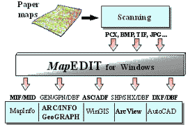
The MapEDIT program for automated graphical data vectorization is intended for digital vector map creation by their raster images on the display of a computer.
MapEDIT accomplishes the following main tasks:
- to fulfill automated/manual vectorization by monochrome and color raster images with separating the map objects into layers;
- to save object attributive data to a database when fulfilling vectorization;
- to reference a map to a coordinate system, to correct distortion of a paper originals;
- to photogrammetrically process raster images of aerial and satellite photographs;
- to control correctness of topological relationship between input objects;
- to export gotten vector maps and databases into the formats GIS and CAD.
Furthermore, MapEDIT allows:
- to process input raster images;
- to put together parts of a vector map;
- to import maps for their editing.
Source Materials
MapEDIT deals with monochrome and color raster images. It supports the formats BMP, PCX, TIFF, JPG, GIF … over 30 formats altogether.
 A map can be digitized by raster parts of the map, digitizing the raster images one by one. If it is necessary MapEDIT enables you to put together the map parts kept in different files and save the result map to a single file, transform (align) a raster image using an arbitrary set of cartographic references.
Difference functions to process raster are provided for to deal with input raster images of low-grade. The following functions are among them:
- deleting one-color objects of a small size (garbage);
- setting off selected colors, deleting a color, changing a color;
- smoothing lines;
- making lines thinner;
- drawing manually (to restore details, which are difficult to distinguish).
Processed raster images can be saved to initial raster formats.
Aerial and Space Photos (Images) Processing
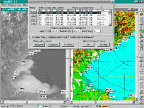 MapEdit v.4.6 provides features for aerial and space photos (images) parameters precise accurate specification (accurate definition) and photos (images) transformation to cartographic projections. Image external and even internal orientation parameters can be specified only partly or with great (significant) errors and are then calculated (specified accurately) using the plane control points. The process of parameters accurate definition can be iterative. The sets of plane control points and the image parameters calculated based on that points can be saved and reloaded from a file later on. The process of plane control points setting is simplified substantially upon the first calculation (accurate definition) of image parameters is done. An operator picks up a point from the image and the corresponding point appears in the map window. The point position can be corrected if necessary. The means of visual monitoring of the plane control points for which the distance between the calculated coordinates and their real values exceeds the maximum observation error enable drawing conclusions about non-discrepancy of the image parameters found and/or an operator's errors while plane control points specification. When the image parameters are specified then the image can be transformed to the cartographic projection of a digital map. The transformation is performed with taking into consideration the terrain altitude. The altitude of each point of the image is calculated by interpolation of the altitude values specified for the plane control points.
Vector Map Creation
MapEDIT allows to set and change the digital map data structure: a list of layers, object types for each layer, parameters of their reflections, tracing conditions, etc. You can also copy the structure of a map created before into a map being created.
You can also use MapEDIT to edit existing vector maps. It provides for data import from files of the format MIF/MID of the geoinformation system MapInfo for this purposes.
Digitizing Automation
Automated tracing is fulfilled in two modes:
- Line tracing.
This mode allows to automatically trace one-color lines of an arbitrary type on a raster image, the coordinates of the resulted trace points being saved. The points belong to the raster line middle. This procedure allows to automatically overcome obstacles on the line such as breaks, forks, intersection with other raster lines.
- Polygon Contouring.
This mode allows to automatically trace contours of one-color square objects of an arbitrary type on a raster image, the coordinates of the resulted contour points being saved. The points belong to the internal border of the area. This procedure allows to automatically overcome obstacles on the line such as breaks, forks, intersection with other raster lines.
Manual vectorization
In case lines and contours are difficult to distinguish, and it is difficult or impossible to automatically vectorize objects, you can input the vector map objects with the tools for manual vectorization. When manually vectorizing, an operator put points on the visible objects on the map.
When manually vectorizing, you can use mode for superposing on raster line. This mode allows to put a drawn point or a segment into the middle of the line being vectorized on the raster image.
Auxiliary Modes
When automatically or manually vectorizing, the position of line (contour) nodes being input can automatically be corrected in accordance with a priori set line (contour) pattern. The following modes for correction are provided for:
- Superposition with vector line.
If the next put node happens to be near a node or a line of a vector object previously created, the node is superposed on them.
- Rectangular/ oblique-angled object.
Object contour nodes are to be superposed so that the polygon linking them forms right/set angles.
- Being parallel to a certain segment.
This mode ensures that the line being input is parallel to a previously set base segment. Different modes can be used simultaneously.
Input of Object Characteristic Features into a Database
Object attributive data are being input in the database when the object is being vectorizing. When completing input of a certain vector map object, the operator can save the information about the object to the database. The type of an object determines a structure of the attributive data being input. The fields are filled with values provided for this type of object by default, or with values input by the operator. Domains can be set for some fields to check values being input by the operator.
Referencing a Map to a Coordinate System
MapEDIT deals with Cartesian and Geographical frame of references. It supports the following projections: of Gauss-Kruger and conical (isogonal, equidistant and isometric). It provides for the user to change projection parameters.
Setting an arbitrary number of reference points with known coordinates enables to get an accurate vector map and to correct paper source distortion connected with its printing, storage and scanning. To accelerate input of cartographic references, input of their coordinates from text file is provided for.
Topological Correctness Control. Data Models.
MapEDIT allows to control correctness of topological relationship between map objects. Found errors can be corrected both automatically and in interactive mode.
MapEDIT supports both objective and line-node (with polygon marks) model of a digital map. You can control correctness of topological relationship between objects for both models.
Data Import
Vector maps can be imported into the MapEDIT program for correction and editing from the following GIS exchange format files:
MIF, MID -MapInfo;
GEN, GPN, DBF -ARC/INFO, Geograph/GeoDRAW;
SHP, SHX, DBF -AraView;
ASC, ASD -WinGIS.
Data Export
Vector maps created by the MapEDIT program and the respective databases can be exported to files of the exchange formats GIS and CAD:
MIF, MID -MapInfo;
GEN, GPN, DBF -ARC/INFO, Geograph/GeoDRAW;
SHP, SHX, DBF -AraView;
ASC, ASD -WinGIS;
DXF, DBF -AutoCAD.
Requirements to a Computer System
MapEDIT 4.6 runs under Windows 95/98/NT.
To run MapEDIT, you need an IBM compatible computer with CPU 486 or Pentium and a capacity of 16 Mb and more, a parallel port and a mouse.
|
|