|
|
 |
|
|
 About the program About the program
|
|
The MapWarp program is intended for coordinate transformation of vector maps in the formats:
· MIF (MapInfo system's exchange format),
· SHP (ArcView system's format).
The MapWarp program is typically applied for correcting vector maps originally created via paper maps or other sources being of low 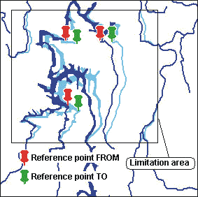 accuracy. To get maps more accurate, you can use field measurement data, for instance, data got by using Global Positioning System (GPS). Map transformation is defined by a set of an arbitrary number of pairs of reference points. The map's characteristic points or separate objects existing on the vector map (geodetic signs, crossroads, building corners, etc.) are to be chosen as reference points. The coordinates of a reference point on the map are input data, the data of the corresponding object's measurements on location are results. accuracy. To get maps more accurate, you can use field measurement data, for instance, data got by using Global Positioning System (GPS). Map transformation is defined by a set of an arbitrary number of pairs of reference points. The map's characteristic points or separate objects existing on the vector map (geodetic signs, crossroads, building corners, etc.) are to be chosen as reference points. The coordinates of a reference point on the map are input data, the data of the corresponding object's measurements on location are results.
The transformation results in the "fitting" of the map to the measured coordinates through exact superposition of the reference points.
- Coordinate transformation is fulfilled by the utility in two stages:
affinity (shift, rotation and scaling of two axes) according to the method of least squares (minimizing sum of squared distances between the reference points "FROM" and their corresponding points "TO");
- nonlinear transformation using triangulation of the map plane between reference points. The transformation results in reducing the destinations between the corresponding reference points to naught, the objects of the map being moved to the nearest reference points in proportion.
When it is necessary to only transfer a part of the map, but not the whole map, the program MapWarp envisages utilization of the limitation area. The limitation area is arbitrary and closed area covering, with some margin, all the reference points used for the transformation. Only will Vector objects' nodes belonging to the limitation area undergo the transformation, shift vector being reduced as approaching the area's boundary. All the input information, including reference points' coordinates and limitation areas, is to be set as tables kept in text files, which can be created or edited easily.
MapWarp runs under Windows 95/98, Windows NT.
MapWarp kit includes 2 installation diskettes, user's guide, a protection key and registration card.
|
|
|
|
|